The Kanopolis Lake Legacy Trail, developed by the U.S. Army Corps of Engineers, offers a glimpse into the area’s rich history before the construction of Kanopolis Dam. This self-guided auto tour starts at the Kanopolis Lake Information Center and travels to 27 historic sites before returning to the Information Center. The complete route is approximately 80 miles. Using existing paved, gravel, and graded dirt roads, the time to complete the tour varies, but it is recommended to allow at least three hours. It is also best not to venture onto dirt roads in poor weather.

Click for larger version
#1 Kanopolis Lake Information Center – The Kansas River Basin is subject to infrequent but surprisingly destructive floods. In 1826, a solid wall of water from the Kansas River reached the Missouri River, submerging the bottoms by 10 to 12 feet. In 1844, William Bent, in traveling across the plains, had to follow the divides between rivers as “every river was full from bluff to bluff.” The newly established town of Ellsworth was flooded in 1867, prompting its relocation to its present site. Following the 1938 flood on the Smoky Hill River, public sentiment turned in favor of flood control. The first project selected for the Kansas City District of the U.S. Army Corps of Engineers was Kanopolis Lake. Construction activities began in 1940 but were halted in 1942 due to World War II. Construction resumed in 1946, and the project was completed in 1948.
#2 Cooley’s Crossing – This river bridge spans the site of what was once known as Cooley’s Crossing. On the river’s north bank, one can still see the remnants of the wagon cuts. Lycuryus J. Cooley settled with his family on the south bank in 1882. Local homesteaders used the Cooley Crossing to travel to Marquette to obtain supplies and to grind their wheat at Bacon’s Mill.
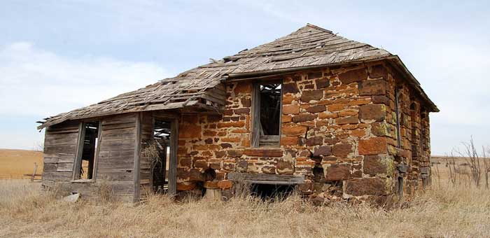
#3 Gile Family Cemetery – The small cemetery located just east of the road on private property is the final resting place of William S. and Adaline P. Gile, early pioneers of the Smoky Hill River Valley. The Giles settled on their ranch in 1872 and lived there until they died in 1904. Before coming to Kansas, Mr. Gile was an employee of the freight firm Irwin, Jackson, and Co., which transported military supplies to posts west of the Missouri River. He was responsible for locating winter feed in the Des Moines, Iowa area for 6,000 oxen. After receiving a severe injury in opposing a cavalry charge during the Civil War, Captain Gile came to Kansas and settled on a farm that was located on both sides of what is now the Kanopolis Dam.
#4 Venango Post Office – Leaving Venango County, Pennsylvania, Ellis Hughes homesteaded in the Smoky Hill Valley in 1868. As the prairie population grew, the Federal Government appointed postmasters to disperse the mail. In 1875, Hughes was appointed postmaster. He named the post office after his former home in Venango County, Pennsylvania. The Venango Post Office was a sandstone structure that served as a post office and a farm dwelling. It was located approximately where the Venango swimming area is now, near the north end of the dam. During construction of the Kanopolis Dam, the former post office served as a project office for the Corps of Engineers.
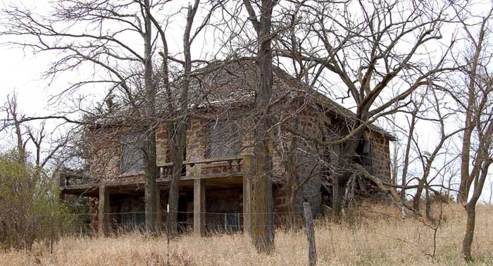
#5 Riverside Division – One of the largest ranches in Kansas began on this site in 1897. The ranch became known as the Sherman Ranch. The Sherman Ranch headquarters was located at this site from 1889 to 1902. As the ranch grew to 40,000 acres, the original headquarters became known as the Riverside Division, one of eight ranch divisions. The ranch was at the forefront of agricultural technology. Riverside’s extensive farm and hog operations boasted a modern feed mill (foundation may still be seen), storage for 40,000 bushels of ear corn and 20,000 bushels of wheat, and a hog house in which over 1,000 pigs were farrowed every year.
#6 Loder Point/Early Settlers Dedication – Loder Point was named after the Loder family, early Ellsworth County farmers and stockmen, whose farm was located below this point before construction of the Kanopolis Dam. The farmers and stockmen came to the area with the establishment of Fort Ellsworth. They became the keystone species in the population base along the river valley. As the farms and ranches grew, the Smoky Hill Valley gained a reputation for prosperity. Area farm names reflected the pride in their accomplishments and optimism for the future. Among the many stewards of the Smoky Hill Valley were: Cedar Lawn Farm, Elmdale Guernsey Farm, Shady Glen Stock Farm, Side View Farm, Happy Hollow Farm, Horseshoe Bend Stock Farm, Spring Valley Stock Farm, and Sunny Slope Farm. This site is dedicated to the settlers of the Smoky Hill Valley.

Kanopolis Petroglyphs
#7 Anderson Stage Station/Petroglyph Site – The true origin of the name “Horsethief Canyon” has been lost in history, but one of the versions begins with the second wave of settlement following the establishment of Fort Ellsworth. Harry Thompkins Anderson built an inn/stage station along the proposed site of a military road near this creek. Anderson had once been deputized to track down some horse thieves. Finding them in Lincoln County, he shot them and returned with the bodies for identification. They were buried in the canyon, thus giving rise to the name of Horsethief Canyon. The 40-foot bluff rising from the shore to the west is called Inscription Rock. Native American people are known to have lived in central Kansas for nearly 5,000 years, but the rock carvings (petroglyphs) are estimated to be no more than 400 years old. The site was first photographed in 1868 by Union Pacific Railroad photographer Alexander Gardner. The Inscription Rock has been described by authorities as “probably the outstanding petroglyph site in Kansas.” Unfortunately, weather conditions and changes in lake elevation have taken their toll, and access to the bluff has been closed to the public. A display at the Kanopolis Lake Information Center features the rock art of these earlier peoples.
#8 Rangeland Vista – The rangeland to the west is an excellent example of the Smoky Hill uplands characterized by thick sandstones of the Dakota formation. The hills and buttes that rise above the surrounding plains once provided excellent vantage points for explorers and Indian raiding parties. Used today as rangeland for cattle, travelers may still enjoy the scenic beauty of the Smoky Hills seen by early buffalo hunters and settlers.
Ruins of an old building in the area where the extinct town of Terra Cotta, Kansas, once stood between Carneiro and Brookville. Photo by Kathy Alexander.
#9 Terra Cotta – To the east, along the railroad tracks, the town of Terra Cotta was laid out in 1878. It was located halfway between Brookville and Ellsworth, along the Kansas Pacific Railroad track. The town was named for the red clay shipped to pottery makers. Between 1886 and 1912, the stockyards of Terra Cotta and Brookville were said to be the busiest between Kansas City and Denver.
Terra Cotta alone shipped three times as many cattle as Brookville. A railway station, store/ post office, community hall, elevator, lumber yard, and hotel once comprised the town of Terra Cotta. Today, nothing remains except the railroad track.
Carneriro Kansas Wellington Home by Kathy Alexander.
#10 Carneiro – The Smoky Hill Trail crossed Elm Creek at the site of the present town of Carneiro. In 1866, the Kansas City and Santa Fe Stage and Mail Line began to travel the military trail. While escorting a stage between Salina and Fort Ellsworth in September of that year, a squad of five soldiers passed the time with target practice on buffalo along the trail. When Indians attacked, the soldiers had used all of their ammunition. Four soldiers were overtaken and scalped. E. W. Wellington from Boston and others developed the Carneiro townsite in 1882. Several extensive sheep ranches were established in the area. Carneiro, which means sheepfold in Portuguese, grew into a center of commerce for the sheepmen.
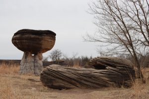
Mushroom Rocks State Park by Kathy Alexander.
#11 Mushroom Rock State Park – Mushroom Rock State Park is a geological phenomenon featuring sandstone spheres balanced on softer sandstone pedestals. The power of erosion weathered away the softer portions of the sandy rock. The spheres of the cemented portions of the sandstone are what we see today. The Smoky Hill Trail crossed in this vicinity, and travelers would venture off the trail to visit the rocks. Many interesting displays of artwork from days past are recorded. Please do not add any of your own.
#12 Faris Ranch/Clear Creek – In September 1860, a group of buffalo hunters settled on Clear Creek at the site of the military road. There were no others in the area except at the Smoky Hill Crossing and the Thompson Creek settlement. The three hunting ranches worked closely together. Time was spent hunting buffalo and wolves, smoking the meat, and curing the hides. Corn was planted, and prairie hay was cut and stacked at all three ranches. In the summer of 1863, ” Jayhawkers” held Irwin Faris (one of the Clear Creek hunters) prisoner while sacking the house. After releasing him, they went on to rob the ranchers at the Smoky Hill Crossing. The same Irwin Faris was bitten by a rabid skunk while on a hunting trip and died of hydrophobia in June 1872.
#13 White Bluffs Ranch – The White Bluffs Ranch was founded in 1882 by the partnership of Bates and Richardson as a sheep ranch. Looking to the east, the white limestone bluffs on the bend of the Smoky Hill River give rise to the name of the ranch. Earlier Native American villages were located on the lowlands below the bluffs. The towering bluffs lend an air of mystery and romance to the landscape. Use them as visual landmarks on today’s tour.
#14 Farisville Post Office – The clump of trees south of the road marks the site of the Farisville Post Office (1875-1911). The post office was named in honor of the Faris brothers who had established a hunting ranch along the Smoky Hill Trail at the Clear Creek crossing in 1860. Unofficially, Mrs. Henry Faris had been postmistress, receiving mail from Fort Harker before 1875. The first postmaster in 1875 was Erskine Becker, who received mail several times a week along a 41-mile route from Ellsworth east to Venango, southeast to Marquette, and east to Lindsborg.
#15 Hummel Bridge – Named after a local family, the Hummel Bridge was built early in the 1900s and moved to this site in 1939 to replace a bridge destroyed by the 1938 flood. The bridge consists of three sections, each a pony-type Pratt truss. In the spring of 1987, the bridge was damaged by floodwaters carrying large debris downstream. The unsafe bridge was closed.
#16 Faris Caves – Seven hundred to 1,500 years ago, the lowlands along the Smoky Hill River were dotted by the earth lodges of Native Americans, now known as the Smoky Hill Complex. These people depended upon the river and adjacent prairie for survival. Rock carvings in the area indicate that later generations of tribes frequented the region. Charles Griffee constructed the caves in the Dakota sandstone bluff in the 1880s. In 1893, William and Winfield Faris purchased the land. Their brothers, Henry and Irwin, had arrived earlier and operated the Faris Ranch on Clear Creek. The Faris family used the caves as a spring house, generator room, and, for a short time, as a schoolhouse.

John Charles Fremont by John C. Buttre, 1859.
#17 Fremont’s Knob – Known as “The Pathfinder,” Captain John Charles Fremont traveled eastward across the plains in July 1844. Returning from his first California expedition, the local legend tells of a band of Indians following at a distance. Upon reaching this mound overlooking the prairie to the southwest, Fremont delivered his conciliatory speech to the potentially hostile Indians. A typical area plant called Fremont Clematis was discovered on Fremont’s expedition across the area. It is sometimes called the leather plant because of the texture of the leaves and flowers. Another name is rattle weed; the dried plant rattles when shaken or when the wind sweeps it across the ‘prairie. If one looks closely, a remnant of the Smoky Hill Trail can be seen just east of the knob. The trail crosses the township road from northeast to southwest. To the southwest, on Government land, the trail divides. The main route goes toward Fort Harker, while the southern route passes by the Black Ranch, whose outbuildings can be seen in the grove of trees. Believed to be a station along the trail, the Black Ranch has intrigued historians for decades. Much that could be learned from the site was lost to a tornado in 1985 and a fire in 1989.
#18 Fort Harker – The success of the military campaign against the Cheyenne Indians in 1864 led to the establishment of Fort Ellsworth. in June 1864. In 1866, it was renamed Fort Harker, and the site was moved to a location above flood level, approximately one mile to the northeast (present site of Kanopolis). It was slated to serve as a base of operations for future Indian campaigns and also as a supply depot and hospital. The quartermaster’s department numbered more than 1,400 civilians. The civilians were associated with the freighting of supplies used in campaigns farther west. Two-fifths of the men hospitalized were from commands far removed from the post. Fort Harker was visited by many famous Western figures. Generals Philip Sheridan, William T. Sherman, Ulysses S. Grant, Winfield Hancock, Nelson A. Miles, Alfred Sulley, and Maurice Forsyth served here, as well as George Armstrong Custer and his 7th Cavalry. Both Buffalo Bill Cody and Wild Bill Hickok were scouts for the military.

Fort Harker Guardhouse by Kathy Alexander.
General Philip Sheridan planned the 1868-1869 winter campaign against hostile tribes from the quartermaster’s home. After this winter campaign, a 3-day peace conference brought together Indian leaders and U.S. Government officials at Fort Harker. Railroad development farther west reduced the need to supply other forts from Fort Harker.
The fort was deactivated in 1873, and the property was sold in 1880. Of the surviving buildings, the guardhouse is maintained as a museum by the Ellsworth County Historical Society. The officers’ quarters at the east end of the parade grounds are now private residences.
#19 Fort Ellsworth – The Fort Riley Road to the southwest was surveyed in 1855. Lieutenant Francis T. Bryan of the U.S. Topographical Engineers recommended bridges on the Solomon, Saline, and the Smoky Hill Rivers. The bridge at the Smoky Hill crossing was constructed in 1856. The bridge was destroyed by the flood of 1858. The road continued to be used by fording the river a short distance south. The earthen approach ramps to the bridge are still visible today. When river levels are shallow, the remnants of the oak pilings are visible.
#20 Wolf Dens – Before the settlement of the area, a wide diversity of wildlife roamed the native plains of Kansas. Buffalo, elk, grizzly bear, black bear, and porcupine were present. Prairie wolves followed the vast herds of buffalo. According to Colonel Henry Inman, quartermaster at Fort Harker, General George Custer and other officers kept wolfhounds just for the sport. The wolf dens in the bluffs along the Smoky Hill River provided the officers the sporting opportunity of the chase.
#21 Buckeye Cemetery – As pioneers depended on one another to overcome the hardships of settling in the area, many chose to be buried with their neighbors in this quiet little setting of the Buckeye Cemetery. Buckeye Cemetery remains a testimonial of the early pioneers in the area between 1866 and 1885. Many pioneers had been buried on their farms and later moved to the cemetery. Family histories may be knitted together by reading the tombstones of an earlier time. The site has served the community in the past with two churches, the first erected in 1884 and the second one in 1930. Buckeye continues to provide fond memories to friends and neighbors who pass by.
#22 Thompson Creek Settlement/Scates Cemetery – The late 1850s brought hunters of buffalo, elk, and wolves to the area. Smoky Hill Thompson established his hunting ranch on the banks of Thompson Creek in 1859. Legend says that Thompson plowed the ground with a team of buffalo instead of oxen. Cheyenne war parties spread across the plains in 1864, forcing the buffalo hunters to retreat east to Salina for protection. Upon establishing Fort Ellsworth in 1864, settlers ventured back into the area. A party of buffalo hunters, led by Robert Hudson, took possession of the abandoned Thompson dugouts. Several claims were made on the Thompson Creek in the spring of 1866. The fall of 1866 brought heartbreak to the dugout with the death of a newborn. The baby was buried on the hilltop not far from the dugout in what later became known as the Scates Cemetery. The small plot on the Scates’ claim was used by the entire Thompson Creek settlement for burial purposes. The records show that many of these early graves resulted from exposure and cholera in 1867 and again in 1872. In the spring of 1938, the granite monument was erected in the memory of the pioneers buried at the Scates Cemetery.
#23 Girl Scout Camp – The slab foundations and fireplace are all that remain of a Girl Scout camp established in the 1950s on this bluff overlooking the Smoky Hill River.
#24 Midland Division – Many of the buildings of the Midland Division of the Sherman Ranch were located below this bluff before the filling of the lake. The Midland buildings consisted of a boarding house, bunkhouse, horse barn, hog sheds, and granary. Each division had its own garden. The land next to the river was planted with alfalfa in which hogs were grazed. Located west of the Midland Division was the Yankee Run Division from which the private cabin area draws its name.
#25 Sherman Ranch – Overlooking the Bluff Creek Valley to the southwest, the holdings of the Sherman Ranch Headquarters can be seen. First known as the Boggs Ranch, M. M. Sherman built his “White House” around which he created a 40,000-acre empire. The Sherman Ranch not only excelled at cattle ranching but led the industry in the use of the latest technology. Steers from a Mexican operation were shipped to the Kansas ranch for grazing. The ranch employed 100 to 200 people, depending on the season. A telephone system connected the eight divisions of the ranch to the headquarters.
#26 Idavale/Larson Ranch – From this vantage point, the confluence of the Bluff Creek with the Smoky Hill River may be seen. The land below the bluffs to the left was once the headquarters of four consecutive ranches. The Powers brothers ran bull trains on the Smoky Hill Trail to Denver before becoming cattlemen in Ellsworth County. The rangeland to the north was known as the Powers Ranch in the 1860s. The ranch was purchased in 1879 by a former Confederate cavalry officer, Captain Eugene Millett. Well known in the cattle trade, Millett made many drives from Texas to trading centers in the north, including Ellsworth. Millett named the ranch ldavale, after his wife. ldavale became a center of social entertainment for the area. An annual Fourth of July picnic was held in the ranch grove. Racing horses were trained on two 2-mile tracks. Purebred cattle were raised and shown at the Kansas City Fat Stock Show. The financial panic of 1893 led to the loss of the property and ranch headquarters. Olaf Larson purchased the ranch and named it the Smoky Hill Ranch.

Kanopolis Lake Marina
#27 Control Tower/Kanopolis Dam – Before the dam’s construction, the Smoky Hill River occupied a broad, flat-bottomed valley with gently sloping sides. The flood plain of the valley was I to 3 miles in width. The river flowed through the valley in a shallow channel, meandering from one side of the valley to the other. The Kanopolis Dam is 15,810 feet long and has a maximum height of 131 feet above the stream bed. Water is released from the lake through a concrete tunnel, 14 feet in diameter and 2,443 feet in length. The control tower contains the operating machinery for discharges. Two gates regulate controlled flow through the tunnel. An uncontrolled outlet maintains normal water flow to the river when the main gates are closed.
Compiled by Kathy Alexander/Legends of Kansas, updated January 2026.
Also See: