
Douglas County, Kansas Pioneers, 1856.
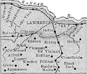
Douglas County, Kansas Map 1889
More Extinct Towns
|
Town |
Post Office Dates | Additional Information |
| Aeolia | None | |
| Akron | 1870 | The post office was only open for a month. It moved from Willow Springs. |
| Aladdin | 1875-1881 | |
| Alexander | None | |
| Alfred | 1875-1878 1882-1902 |
A hamlet in the southwestern part of Douglas County, it was ten miles west of Quayle, the nearest railroad station, and about four miles west of Lone Star. |
| Appanoose | 1857-1860 1870-1902 |
First established in Franklin County before moving to Douglas County. In 1910, it was described as a small hamlet situated in the extreme southwestern corner, eight miles southeast of Overbrook, the nearest railroad station. At that time, it had a population of less than 20. |
| Baden | 1883-1886 1888-1891 |
Situated on the Santa Fe Trail, a marker commemorates the old site. |
| Bald Eagle | None | |
| Barbers Station | None | |
| Belevue | None | |
| Belmont | None | |
| Benicia | None | |
| Black Jack Point | None | |
| Blackfau, aka Blackfaw | None | |
| Blanton | 1855-1856 | Blanton’s Bridge at Oregon & California Trail crossing of the Wakarusa River south of Lawrence in 1855. Napoleon Blanton, Proprietor. The 1855 Territorial Legislature authorized the toll bridge. Napoleon Blanton. |
| Bloomington | 1855-1858 | Bloomington merged with Clinton. |
| Blue Jackets Crossing | None | Also called Blue Jackets Ford. Crossing of the Wakarusa River in about 1855. George Bluejacket, Proprietor. Settlement was incorporated as “Sebastian” and consisted of a hotel run by Charles or George Bluejacket, who also operated a ferry, and a store operated by William “Dutch Bill” Greiffenstein. William C. Quantrill crossed here in 1863 to attack Lawrence. |
| Blue Mound | None | |
| Brooklyn | None | Brooklyn, also called Brookline, was settled as early as 1855 and was incorporated in 1858. William Quantrill’s men destroyed all but the saloon/general store as they retreated from burning down Lawrence in August 1863. Today, only a Santa Fe Trail marker exists at the old townsite. |
| Calcutta | 1875-1881 | |
| Camp Sackett | None | |
| Camp Saunders | None |
 Camp Saunders 1856 This was a Pro-Slavery stronghold, located 12 miles southwest of Lawrence, Kansas Territory. It was destroyed by Free-State settlers in 1856. |
| Chandler | None | |
| Chester | None | |
| Clearfield | 1885-1900 | A small hamlet in the southeastern part of Douglas County, it was located on a branch of the Wakarusa River, four miles east of Vinland. In 1910, it had fewer than 20 inhabitants. |
| Collinwood Farm | None | |
| Coon Point | None | |
| Douglas | 1855 | Also called Douglas City. The post office moved to Lecompton. |
| East | None | |
| Echo | 1874-1875, 1878-1900 | |
| Elysian Plains | None | |
| Excelsior | None | |
| Fall Leaf | None | |
| Gideon | 1883-1902 | A hamlet located in the central part of Douglas County, it was about eight miles southwest of Lawrence. |
| Glasgow City | 1875 | |
| Glen Burn | 1856-1857 | |
| Glendale | 1881-1894 | |
| Grover | 1886-1895 1897-1899 |
 ATSF Tracks Located in the extreme northwestern part of the county, it was situated on the Atchison, Topeka & Santa Fe Railroad about 15 miles northwest of Lawrence. |
| Hesper | 1868-1900 |
 Hesper Friends Church Hesper was founded in 1858 by Quakers who wanted to support the free-state cause. In 1884, the Hesper Academy was established with the objective “to advance the cause of education, morals, and religion.” The school building is a two-story frame, erected at a cost of $3,500. Hesper Academy did preparatory work for any college or university in the West. It was wholly dependent on tuition fees for its support. In 1910, Hesper had a population of 36. Unfortunately, the town of Hesper and the academy didn’t make it. The school closed in 1912. It was located about three miles southeast of Eudora on N. 1100 Rd. There are still a few homes in the area, as well as the Hesper Friends Church. |
| Hog Back | None | |
| Hole in the Rock | None | |
| Holling | 1869-1900 | Holling was located in the southern portion of the county, eight miles from Lawrence and three miles from Vinland, the nearest railroad town. |
| India | None |
 ATSF Railroad Situated along the Atchison, Topeka, & Santa Fe Railroad south of Lawrence, Kansas. |
| Jefferson | 1865-1872 | Also called Jefferson City, it was first established in Jefferson County. |
| Kanwaka | 1857-1870 1898-1900 |
 Kanwaka Hall Located four miles west of Lawrence, the area that was not yet a town was first settled in 1854. Its name combines the names of the Kansas and Wakarusa Rivers. It is located at the intersection of U.S. Highway 40 and Stull Road. |
| Kennedy Valley | None | |
| Kezerville | 1856 | |
| Lake View | 1898-1914 |
 Fishing at Lake View Also known as Horseshoe Lake, this hamlet in northern Douglas County was located on the Atchison, Topeka, & Santa Fe Railroad and a branch of the Kansas River, five miles northwest of Lawrence. In 1910, it had a money order post office, telegraph and express facilities, and a population of 15. |
| Lane | 1855-1856 | |
| Lapeer | 1873-1902 | One of the old settlements of Douglas County, it was located in the southwest corner, in the Wakarusa Valley, about eight miles northeast of Overbrook, the nearest railroad station. The first settlers arrived in 1855, and a post office was established the following year. During the summer of 1856, a store was opened, and several houses were erected, but the town practically died after the traffic on the Santa Fe Trail was abandoned. |
| Louisiana | 1856-1857 | |
| Marshall | None | |
| McKinney | 1857-1868 | |
| Media | 1878-1903 | The post office moved from Prairie City. |
| Midland | None |
 Midland Railroad A hamlet located on the Union Pacific Railroad about four miles north of Lawrence. In 1910, the population was 50. |
| Miller’s Springs | None | Also called Miller and Millerburg. |
| Mission Camp | None | |
| Mount Aeolia | None | |
| Mount Hope | None | |
| Mount Oread | None | Mount Oread is a hill in Lawrence, Kansas, upon which the University of Kansas and parts of Lawrence are located. |
| Mount Vernon | None | |
| Neoma | None | |
| Nevada City | 1855-1857 | |
| New Boston | None | |
| New Haven | None | |
| Noria | None | Located in Wakarusa Township, just a few miles east of Lawrence along the line of the Atchison, Topeka & Santa Fe Railroad. |
| North Lawrence | 1865-1885 | First established in Jefferson County, the name was changed to North Lawrence in December 1872. |
| Orbondale | None | Also known as Auburndale. |
| Ottawa | None | |
| Pacific City | None | |
| Palmyra | 1857-1862 | The town merged with, and the name was changed to Baldwin City. |
| Prairie City | 1856-1878 | The post office moved to Media. |
| Red Deer | None | |
| Redemption City | None | |
| Saint Charles | None | |
| Salem | None | |
| Scottsville | None | |
| Sebastian | None | George Bluejacket was an incorporator of Sebastian. |
| Seigel | 1900-1901 | |
| Sibley | 1884-1934 | A hamlet located on the Atchison, Topeka, and Santa Fe Railroad, seven miles south of Lawrence. In 1910, it had a post office, express facilities, and a population of 25. The railroad name was Sibleyville. |
| Sigel | 1862-1874 1875-1888 1891-1896 |
 Sigel school. Also known as Sigel Station, this small town was situated on the St. Louis, Lawrence, and Western Railroad. The life of the railroad and Sigel Station was short. It was established in 1874 and was defunct by 1877. The townsite had School District No. 8. The old townsite was flooded when Clinton Lake was built. |
| Stanton | None | |
| Stewart | None | |
| Titus/Fort Titus | None |
 Fort Titus A Confederate stronghold. Near Lecompton, voting precincts 1854 and 1855. A replica fort has been established in Lecompton. |
| Tokeska | None | |
| Tyler Place | None | Vacated 1895. |
| Wakansa | None | |
| Wakarusa | 1857-1866 | |
| Wakefield | None | |
| Walker City | None | |
| Washington | None | Incorporated 1855. Near Big Springs on the California Trail. |
| Washington Creek | 1873-1882 | |
| Weaver | 1891-1903 | A hamlet that was located in the extreme northeastern portion of the county on the south bank of the Kansas River, about three miles northeast of Eudora. |
| Wheatland | 1856 | |
| Wilson’s Springs | None | Probably Willow Springs. |
| Winchester | None | |
| Worden | 1884-1904 |
 Worden Building Also spelled Warden, this hamlet was located in the south-central part of the county, about seven miles west of Baldwin City. In 1910, the population was 26. |
| Yankee Town | None | Later, it was part of Lawrence. |
| Yellow Springs | None |
©Kathy Alexander/Legends of Kansas, updated January 2026.
Also See:
One-Room, Country, & Historic Schools of Douglas County
See Sources.